|
Things to take note of:
Activity 1: Factors Affecting Weathering

Direction:
Results: 
It didn't change much visually. Although the parts that got wet, did dissolve a bit.

Most of the polvoron crumbled, except for that big chunk which remained stubborn. I actually tried to shake it even longer after the experiment, just to see what it would take for it to crumble but it still stayed intact.

Here, the polvoron also crumbled, although the combination of the water and the shaking, made most of it stick in the container. A bit of the polvoron also got stuck in the lid. This was the hardest of the 3 to clean up 'cause the polvoron just refused to budge.
Container A was an example of chemical weathering, like acid rain on a rock. Container B exemplified physical weathering through the motion brought on by shaking it, like boulders breaking up due to an earthquake. Meanwhile, Container C experienced both kinds of weathering resulting in a paste like texture that stuck to the container, much like the formation of grus cemented by water. Both container B and C broke down, but container B seemed to have the crumbliest texture.
Activity 2: Evidence of Weathering and Erosion


I’ve been putting off doing this activity because despite the instructions, I wanted to take a photo of something grand. I wanted to take a photograph of something in the environment and not a man-made structure. As I live in the city, I wanted to go on a trip to make that photograph possible. But, alas, I couldn’t make the trip and I’ve been reminded again, that sometimes, simple is better. I decided to just do as the instruction said, I grabbed a camera went around the block and took this photograph of the back side of a condominium.
What first drew me to it was the rusting grayish structure that was overhanging from the building. It’s an example of chemical weathering through oxidation. Just in front of the building was a part of the LRT 2 line. I noticed that there were cracks on it and that some parts were corroded. As it was in the middle of traffic, the heavy air pollution could have caused acid rain, which ultimately, caused the corrosion.
Things to take note of:
Activity

The Philippine plate and the Eurasian plate are converged, forming a subduction zone under the Philippines. This also caused the Philippine trench to form. Most of the Philippine volcanoes are found near this trench and other convergent zones and trenches around the country.

For instance, the formation of Mount Pinatubo was caused by the convergence of the Philippine and Eurasian plate.
Things to take note of:
Activity 4-1 
Faults in the Philippines
4. Valley Fault System
8. Sicalao Ridge Fault 9. Dummon River Fault 10. Tabuan River Fault 11. Abra River Fault 12. Chico Fault 13. Ambuklao Fault 14. Tubao Fault 15. Pugo Fault 16. Tabuan River Fault 17. Taboan River Fault 18. Divacalan Fault 19. East Cordillera Fault 20. Hapap Fault 21. Addalam Fault 22. East Zambales Fault 23. Iba Fault 24. Lubang Fault 25. Central Marinduque Fault 26. Aglubang River Fault – Mindoro Earthquake | November 15, 1994 | Magnitude: 7.1 27. Legazpi Lineament 28. Northern Samar Lineament 29. Central Samar Lineament 30. Southern Samar Lineament 31. Tablas Fault 32. Central Mindoro Fault 33. Southern Mindoro Fault 34. West Panay Fault- Panay Earthquake | June 14, 1990 | Magnitude: 7.1 35. Central Negros Fault 36. North Bohol Fault – Bohol Earthquake | October 15, 2013 | Magnitude: 7.2 37. East Bohol Fault – Bohol Earthquake | February 08, 1990 | Magnitude: 6.8 38. Cabanglasan Fault 39. Tagoloan River Fault 40. Lanao Fault System 41. Davao River Fault 42. Tangbulan Fault 43. Zamboanga Fault System Trenches in the Philippines
Plate Tectonics Puzzle

I love jigsaw puzzles, so I solved the puzzle just as I would a normal jigsaw puzzle, by matching the pieces together that I think would fit. To make it easier, I first arranged the pieces as how they appear in the present, then proceeded to match them by moving each piece without lifting them. This would simulate the “drifting” part of the Continental Drift Theory. After I was done, I checked if I was right by making sure that the finished image made sense. For instance, I was able to connect a desert that run through Antartica, Africa and South America. There were also basalt traces that connected Europe and Asia to both North America and Africa. Lastly, the presence of fossils on each continent connected them, like the fossils of Rhynchosaur that were found in India, Africa and South America, or the remnants of amphibians from Australia, Antartica, Africa and South America.
Things to take note of:
Activity 2-1 For this activity, I first thought of doing it digitally, meaning download a picture of the topographic map of Metro Manila then use an image software to digitally trace it. However, I wanted to do it manually, so I got this map of NCR at National Bookstore. I know that using a map online where I can really zoom in, would generate a much more detailed trace of the streams, but I thought I was able to capture the general outline, nonetheless. As you can see from the traced lines, with its branch like appearance, that the streams surrounding Metro Manila is dendritic. 
Activity 2-2 Both the earth and the melon have a hard, outer crust. The edible part of the melon represents the mantle which is the thickest part of the earths’ structure. The core is represented by the seedy part of the melon. 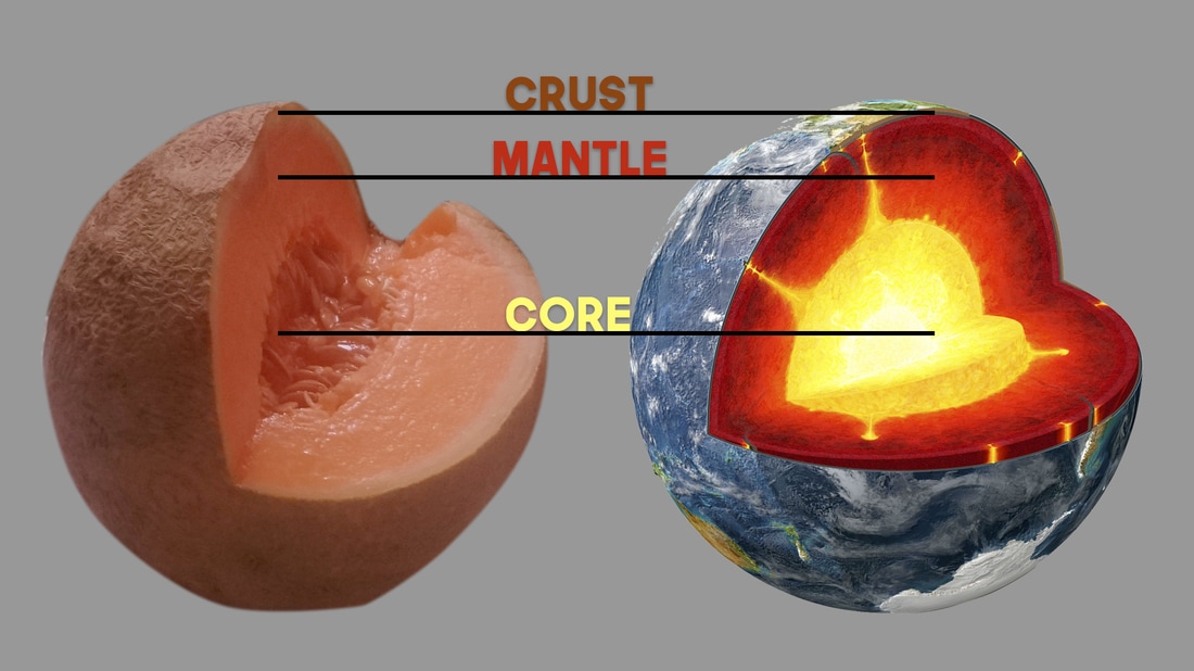
The image of the Earth, was taken from :http://www.dkfindout.com/uk/earth/structure-earth/, The image of the Melon, was taken by me.
|


